
Seas and Islands in Japan


About sea around Japan
Japan is an island country.
The mainland consists of four large island, and and they account for over 95% of the whole of Japan.
The other small islands are around the mainland and some of them are dotted on a line in the vast ocean.
Total number of the islands in Japan is 14,125, and Japanese people live in 416 islands of them.
The land area is not so large, but the total length of the coastline is the sixth longest in the world.
The islands are dotted in wide area.
The territory reaches from subarctic zone to subtropical zone.
Because of such geographical features, various climates appear by region.
Therefore, various scenic spots and resort areas of sea are throughout Japan.
Seas and islands in eastern Japan
Hokkaido Region
Cape Soya (宗谷岬)

Cape Soya is the northernmost cape in Japan.
Wakkanai city is the northernmost city in Japan, and the cape is located about 25 km northeast of the city.
The area around this cape is Soya Misaki Park.
There are a few monuments, and wild Hokkaido sika deer are seen in the grassland.
From the cape, you can see Sakhalin Island in Russia.
Rishiri Island (利尻島)

Rishiri Island is an island located about 40 km southwest of Wakkanai city.
It is a nearly round island.
It is about 15 km from east to west and 17 km from north to south in width.
There is a volcano Mt. Rishiri in the center of the island, and whole island is full of nature.
Rebun Island (礼文島)

Rebun Island is an island located about 10 km northwest of Rishiri Island.
It is about 5 km from east to west and 20 km from north to south in width.
It is not a volcano island, and there are low mountains are in the island.
The scenery of the coast and small lake are popular.
Drift ice in Okhotsk Sea

Drift ice comes ashore around the northeastern coast of Hokkaido facing Okhotsk Sea from late January to early March.
It is called "Ryuhyo" (流氷) in Japanese.
The sea water is frozen in the northern part of the Okhotsk Sea, and is carried toward the south by sea currents.
Abashiri city and Monbetsu are popular sightseeing cities for the drift ice.
The cruising ships in ryuhyo are operated in the season from the ports.
Shiretoko Peninsula (知床半島)

Shiretoko Peninsula is a long peninsula extending about 70 km toward northeast like a horn.
The northern half of the peninsula is uninhabited and is covered by primeval forest.
So, the area was registered as a World Natural Heritage Site.
There are Utoro and Rausu villages at the entrance place to the area.
These are the base of sightseeing for Shiretoko Peninsula.
In winter, drift ice is seen on the Okhotsk Sea side.
Notsuke Peninsula (野付半島)

Notsuke Peninsula is the biggest sand spit in Japan.
It extends from the eastern coast of Hokkaido, and the length is 26 kilometers.
There is Notsuke Bay (another name is "Odaitou") between the mainland and the sand spit, and the tourists can go to the the sand spit by cruising boat.
You can see the unique sceneries such as the fields of blighted primeval forest and wild flowers.
Cape Nosappu (納沙布岬)

Cape Nosappu is the easternmost place of Japan where the common tourists can visit.
It is located about 20 km east of Nemuro city which is the easternmost city of Japan.
There are a few islands near the cape, but these were occupied illegally by Russia (former Soviet Union) in 1945.
We can see the islands from here, but former island's people still cannot return to the islands.
Cape Erimo (襟裳岬)

Cape Erimo is a sharp corner at the center of bottom on a map of Hokkaido.
It is the place that Hidaka Mountain range falls into the Pacific Ocean directly.
So, steep cliffs surround the cape and rock reefs run from the cape to 7 km off the coast.
It is windy at most days of year around this cape, and fog often rises.
Cape Chikyu (地球岬)

Cape Chikyu is located south of urban area of Muroran city.
It is the northern entrance of Uchiura Bay and the east side faces the Pacific Ocean.
The coastline around this cape has steep cliffs over 100 meters high,
The observatory is at the level of 147 meters.
When we look at the horizon there, we realize that the earth is round.
Shakotan Peninsula (積丹半島)

Shakotan Peninsula is a peninsula extending from the west of Otaru city to the northwest.
Whole area is mountainous and small villages are dotted along the coastline.
And there are various scenic spots of the sea are along the coastline.
The color of the sea is beautiful.
Sea urchin in summer is a specialty of Shakotan Peninsula.
Okushiri Island (奥尻島)

Okushiri Island is a small island to the southwest of Hokkaido.
There is no bear, fox and venomous snake in this island, so here is a paradise for hares, raccoon dogs, common pheasant, etc.
There are a few unique spots by the coast.
Sea Urchin, abalone, squid are the tasty specialties of this island.
Tohoku Region
Hotokegaura (仏ヶ浦, Aomori Pref.)

Hotokegaura is a part of western coast of Shimokita Peninsula shaped like an ax.
It faces Tsugaru Strait between Hokkaido and Honshu islands.
There are white uniquely shaped rocks and cliffs along the coast.
"Hotoke" means "Buddha".
The height of some rocks and cliffs are more than 100 meters, and they looks like great statue of Buddha.
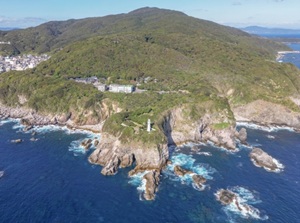
Cape Tappi (竜飛崎, Aomori Pref.)

Silhouette of Hokkaido island at Cape Tappi
Cape Tappi is at the north tip of Tsugaru Peninsula facing Tsugaru Strait.
There is Hokkaido Island about 20 km off.
A lighthouse and an observatory are on the hill, and you can see the island when it is fine.
Just under this cape, there is Seikan Undersea Tunnel connecting Aomori and Hokkaido and Hokkaido Shinkansen runs through the tunnel.
JR Gono Line (五能線)

JR Gono Line is a local railway of JR, and it connects Hirosaki city in Aomori Prefecture and Noshiro city in Akita Prefecture (about 147 km).
About half section of the line faces the Sea of Japan directly, so it is the most scenic line of JR.
The passengers can watch at the scenery of varied coastline and the sea from the train window for a long time.
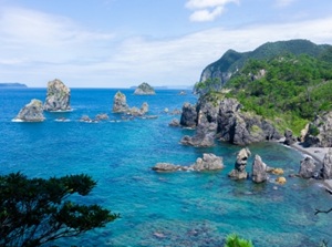
Sanriku Coast (三陸海岸, Iwate Pref.)

Kitayamazaki in Sanriku Coast
Sanriku Coast is the coastline of Aomori, Iwate, Miyagi Prefectures, and it faces the Pacific Ocean.
The length is about 280 km in a straight line.
But, because it has a sawtooth shaped coastline, the real length of the coastline is about 600 km.
The whole area is very steep and high cliffs are dotted.
There are many popular sightseeing spots in this wide area.
Miyako, Kamaishi, Kuji cities are the bases to travel around this area.
Oga Peninsula (男鹿半島, Akita Pref.)

Hachiboudai observatory in Oga Peninsula
Oga Peninsula is the only peninsula which expands into the Sea of Japan in Tohoku Region and is in Akita Prefecture.
The area is well-known for "Namahage" which is a traditional event that scary devils visit in all houses and scold lazy people.
There are some scenic spots and an onsen resort in the peninsula.
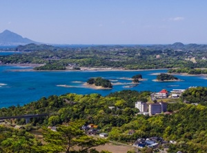
Matsushima (松島, Miyagi Pref.)

Matsushima is a scenic bay with many small islands.
It is located 20 km northeast of central Sendai city.
Since ancient times, Matsushima has been known as a very scenic place.
Pleasure boats are operated and the tourists can enjoy the view on the boat.
And, there are the famous buddhist temples, Zuiganji and Entsuji, near the coast.
Kanto Region
Choshi (銚子, Chiba Pref.)

Choshi is a city located at the eastern tip of Kanto Region.
There is Cape Inubo, and the first sunrise is seen in Honshu island.
Choshi fishing port is one of the biggest catcher of fish in Japan.
And, there are two soy sauce factories.
In addition, small Choshi-dentetsu railway runs in the city and is unique and popular.
Umi-hotaru (海ほたる, Chiba Pref.)

Umi-hotaru is a rest area on the expressway connecting Tokyo area and the southern part of Chiba Prefecture.
The expressway crosses Tokyo Bay and the length is 14 km.
Umi-hotaru is just at the center of Tokyo Bay.
The location is on an artificial island in Tokyo bay, so it has good views.
Kamogawa, Katsuura (鴨川, 勝浦, Chiba Pref.)

Kamogawa and Katsuura are the towns in Boso Peninsula facing the Pacific Ocean.
These are one of the popular seaside resort areas in Kanto region.
Popular aquarium, unique island, Buddhist temples are around the coast.
Enoshima (江の島, Kanagawa Pref.)

Enoshima is a small island connected by a bridge and is near Kamakura city.
The coastline around Enoshima is a popular scenic area.
The area is close to Tokyo and Yokohama, so it is popular amongst young people.
There is a Shinto shrine and scenic places are in the whole island.
Jogashima (城ヶ島, Kanagawa Pref.)

Jogashima is a small rocky island by the tip of Miura Peninsula forming the entrance of Tokyo Bay.
A bridge connect the island and the mainland.
The narrow sea between Jogashima and the mainland is Misaki Port, and the tunas unloaded at the port are popular.
The flat island is a natural park.
Izu Islands (伊豆諸島) & Ogasawara Islands (小笠原諸島)

Hachijojima island
Izu Islands are located 100 to 700 km south of Tokyo, and have about 100 small islands.
Ogasawara Islands are located 900 to 1,100 km south of Tokyo, and has about 30 islands.
They are from temperate to subtropical zones and most of them are volcanic islands.
There is a lot of nature and there are few gorgeous resort areas.
Ogasawara Islands were registered as a World Natural Heritage site.
Seas and islands in central Japan
Koshin-etsu Region
Sasagawa-nagare (笹川流れ, Niigata Pref.)

Flying sea gulls near pleasure boat around Sasagawa-nagare
Sasagawa-nagare is a coast facing the Sea of Japan, and is located in the northern part of Niigata Prefecture.
Many uniquely shaped rocks are seen, and the clear water of the sea and the view of sunset are beautiful.
Pleasure boats are operated, and feeding the flying sea gulls on the boat is popular.
Sado (佐渡, Niigata Pref.)

Entrance of Sado Gold Mine
Sado is a comparatively large island in the Sea of Japan and is located about 45 km west of Niigata city.
This island had been a penal colony in the ancient times.
The gold mine was developed in 1601, and Sado became the territory under the direct control of Edo Government.
Because of the history, Sado became an island with unique culture.
There are some historical spots, old towns, the Japanese crested ibis registered as a special Japanese natural treasure, etc. in the island.
The gold mine was designated a World Heritage Site in 2024.
Hokuriku Region
Amaharashi coast (雨晴海岸, Toyama Pref.)

Amaharashi coast is located southwest of Toyama Bay and is in the northern part of Takaoka city.
There is a small rock island with a few trees on the top.
The view of Tateyama Mountain Range beyond the island and Toyama Bay is beautiful and popular.
Noto Peninsula (能登半島, Ishikawa Pref.)

Shiroyone Senmaida rice terrace in Wajima city
Noto Peninsula is the northern part of Ishikawa Prefecture.
It expands northward into the Sea of Japan.
Small town and scenic spots are dotted along the coastline facing the Sea of Japan.
Nanao city with Wakura onsen resort and Wajima city on the northern coast are the bases of sightseeing.
The whole area was seriously damaged in the earthquake on January 1, 2024.
Now, this area is slowly recovering.
Guide to Noto Peninsula in Ishikawa Prefecture
Tojinbo (東尋坊, Fukui Pref.)

Tojinbo is the very steep rocky coast facing the Sea of Japan.
It is located about 20 km north of Fukui city.
The cliff with a lot of columnar joints for 1 km is one of the rare places in the world.
So, it is designeted as a national natural treasure.
Mikata-goko (三方五湖, Fukui Pref.)

Mikata-goko is a group of five small lakes facing Wakasa Bay.
It is located about 20 km west of Tsuruga city.
All lakes are connected with a narrow channel or a canal.
The shape of the lake is complicated and the hills between the lakes make the appearnce of beautiful scenery.
A scenic road is set up and a pleasure boat is operated.
Tokai Region
Shimoda (下田, Shizuoka Pref.)

Shimoda is a city near the southern tip of Izu Peninsula in Shizuoka prefecture.
The town is along the cove facing the Pacific Ocean, so there are some scenic spots of sea around the city.
Japan had took up the seclusion policy as a foreign policy since 1633, but Perry who was an United States Navy officer visited Shimoda to urge Japan to open the country in 1854.
This led to finish the samurai nation in 1868.
In Shimoda city, there are some historical spots about them.
West coast of Izu Peninsula (西伊豆, Shizuoka Pref.)

Dogashima coast in West coast of Izu Peninsula
The west coast of Izu Peninsula faces Suruga Bay.
The coastline has few flat lands and the visitor can see the varied scenes of the sea.
It faces west, so there are some scenic spots that the sunset is beautiful.
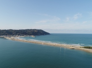
Miho no Matsubara (三保の松原, Shizuoka Pref.)

Miho no Matsubara is a beach with pine grove in Shizuoka city.
It is a small peninsula of a sand spit and faces Suruga Bay.
There are about 54,000 pine trees along the beach for 7 km.
And, it is one of the best places to see Mt.Fuji.
When Mt. Fuji was registered as a World Heritage Site, this place has also been included.
Meoto-iwa (夫婦岩, Mie Pref.)

Meoto-iwa is a pair of rocks near a coast, and it is close to Ise Shrine in Mie Prefecture.
The name means "rocks of husband and wife".
The two rocks are connected with the sacred ropes.
There is Futami-Okitama-jinja (二見興玉神社) on the shore. Meoto-iwa is enshrined by the shrine.
Toba (鳥羽, Mie Pref.)

Toba is the entrance city of Shima Peninsula and it is also located to the east of great Ise-Jingu shrine.
It is a sea side resort city and there are many hotel and ryokans.
Japanese cultured pearls were created in Toba for the first time in the world in 1893.
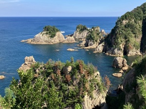
Shima Peninsula (志摩半島, Mie Pref.)

Scenery of Ago Bay in the southern part of Shima Peninsula
Shima Peninsula forms the entrance of Ise Bay and Toba city is at the northern part of the penninsula.
The coastline is the ria coast and highly indented.
There are some spots to see the beautiful scenery of the sea.
Ama is a traditional woman fisher who dives into the sea near and catches expensive abalones and the other shells or seaweeds.
Of course, they worked to get the shells for pearl.
About 500 amas live in this peninsula.
Shichiri-mihama (七里御浜, Mie Pref.)

Shishi-iwa (Lion rock) in Shichiri-mihama
Shichiri-mihama is a straight coast in Kumano city in the southern end of Mie Prefecture.
It is a part of Kumano-Kodo which are the ancient pilgrimage routes designated a UNESCO World Heritage site.
The length of the coast is actually about 20 km.
The beach is filled with smooth round stones and the picking of the stone is prohibitted.
There are a few spots of unique rocks.
Seas and islands in western Japan
Kansai Region
Amanohashidate (天橋立, Kyoto Pref.)

Amanohashidate is a scenic sandbar.
It is in Kyoto Prefecture, but it is located near the Sea of Japan far from central Kyoto city.
The shape of the sandbar looks like a dragon going up to heaven, so it has been a popular place since ancient times.
There are the observatories to see it on the hills and the pleasure boat sailing around the sandbar is operated.
Shirahama (白浜, Wakayama Pref.)

Shirarahama beach in Shirahama
Shirahama is a resort town and is in the southern part of Wakayama Prefecture.
The coastline faces the Pacific Ocean and the climate is warm.
The name means "white beach".
"Shirarahama" is the main beach and the white sand in the beach is a beautiful.
In addition, it is an onsen resort, so there are some hotels in the area.
Kushimoto (串本, Wakayama Pref.)

Hashigui-iwa in Kushimoto
Kushimoto is a town at the southern edge of Kii Peninsula, and it is also the southern edge of Hoshu island.
A warm ocean current called "Kuroshio" flows near this area, so the area is warm.
Cape Shionomisaki is the southernmost place.
And, there are the unique rocks "Hashigui-iwa" along the coast.
Akashi-Kaikyo Bridge (明石海峡大橋, Hyogo Pref.)

Akashi-Kaikyo Bridge is a suspension bridge for cars and crosses over Akashi Channel.
It connects Akashi city and Awajishima island, and it is on an important route from Kansai region to Shikoku Island.
On the Akashi city side, there are a park and a museum, and the guided tour of the bridge is held.
Chugoku Region
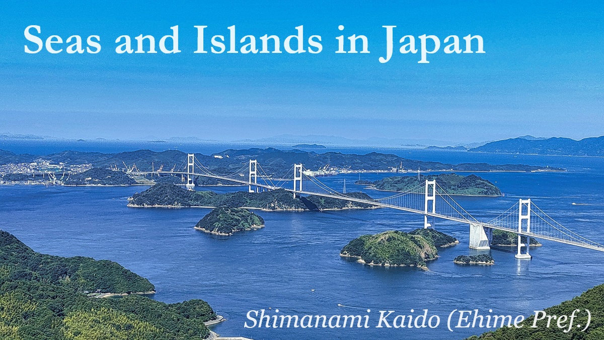
Shimanami Kaido (しまなみ海道, Hiroshima & Ehime Prefs.)
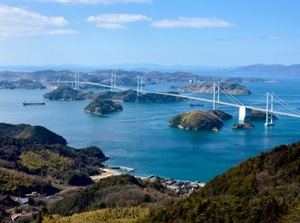
Shimanami Kaido is an expressway about 60 km long connecting Honshu Island and Shikoku Island.
The route passes six small islands in Seto Inland Sea.
The whole route has scenic view.
Bicycles is allowed to pass on the route, so it is a popular cycling course.
Tomonoura (鞆の浦, Hiroshima Pref.)
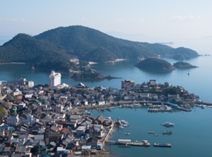
Tomonoura is a small port town facing Seto Inland Sea and is located to the south of Fukuyama city.
There is an old town around the cove.
The ships sailing on the sea had waited for the change of the flow in this port in the old times.
And, many temples and shrines had been built since the ancient times around this port.
Okunoshima (Rabbit Island) (大久野島, Hiroshima Pref.)
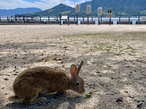
Okunoshima is a small desert island, and it is located about 3 km off the coast in Takehara city.
It is said that the first eight rabbits in this island were moved from an elementary school in Takehara city in 1971.
Now, about 400 wild rabbits are living in the island.
The food for the rabbit is sold at the ferry port in Takehara city.
Tottori Sand Dunes (鳥取砂丘, Tottori Pref.)
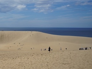
The number of sand dunes in Japan isn't a lot.
Among them, Tottori Sand Dunes is the most popular sand dunes and is a sightseeing spot.
It faces the Sea of Japan and is near Tottori city.
The scenery is rare in Japan, and it has been designated a national monument.
Uradome Coast (浦富海岸, Tottori Pref.)
Uradome Coast is a ria coast about 15 km long, and is located to the northeast of Tottori Sand Dunes.
Especially, the coastline about 4 km long in the western part has many small rocky islands, cliffs, caves and sand beaches.
The scenery contrasts with Tottori Sand Dunes.
It is a national-designated site of scenic beauty and natural monument.
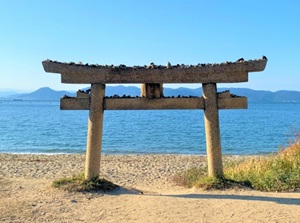
Inasa Beach (稲佐の浜, Shimane Pref.)
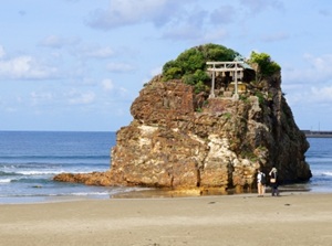
Inasa Beach is located 1.2 km west of sacred Izumo-taisha shrine.
On the sand beach, there is a big rock called "Bentenjima".
This place is in relation to Japanese myth and Izumo-taisha shrine.
It is said that all gods in Japan gather here in a day in autumn.
So, here is not a resort beach.
Oki Islands (隠岐, Shimane Pref.)
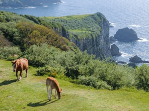
Oki Islands are located about 70 to 100 km north of Shimane Peninsula in the Sea of Japan.
In the middle ages, Oki was a place of exile and has the history that two Emperors were exiled.
Main four islands have the history, unique culture and rich nature.
To Oki Islands, ferry and airlines are operated.
Oumijima island (青海島, Yamaguchi Pref.)
Oumijima island is an island in the Sea of Japan.
It is just near Nagato city and is connected by a bridge.
The northern coast faces the Sea of Japan directly, so there are sheer cliffs and rocks along the coast.
The landscape is called "Alps in the sea".
Tsunoshima Bridge (角島大橋, Yamaguchi Pref.)
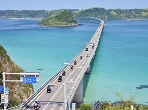
Tsunoshima Bridge is a bridge connecting Tsunoshima island and the mainland.
It is located about 50 km north of Shimonoseki city.
The bridge is 1,780 meters long and was completed in 2000.
The color of the sea is beautiful like a tropical resort.
The beautiful landscape has sometimes been used in TV commercials of car since the 2010s, so here became a popular spot.
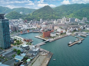
Shimonoseki (下関, Yamaguchi Pref.)
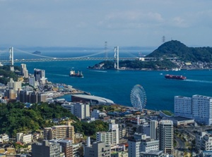
Shimonoseki city and Kanmon Straits
Shimonoseki is the city located at the western end of Honshu Island.
It faces Kanmon Straits like a wide canal and is the entrance to Kyushu island.
There are some historical spots as an old port town.
And, Fugu (pufferfish) as high-quality fish is a specialty of Shimonoseki.
Shikoku Region
Shodoshima (小豆島, Kagawa Pref.)
Shodoshima is the second largest island in Seto Inland Sea.
It is located 25 km southeast of Okayama city and 20 km northeast of Takamatsu city in Shikoku island.
The cultivation of olive is well-known in the mild climate.
And, Shodoshima is known as a set of a novel that a woman teacher and the students in Shodoshima had been drawn into the World War II.
There are various sightseeing spots in the island.
Naoshima (直島, Kagawa Pref.)
Naoshima is a small island in Seto Inland Sea.
It is located about 15 km north of Takamatsu city.
In the 1980s, the mayor thought that he wanted to change this island to a cultural place.
So, Naoshima became an island of modern art.
There are some museums, some outdoor art works are dotted in the island.
Honjima (本島, Kagawa Pref.)
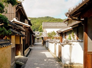
Old town in Honjima
Honjima is one of Shiwaku Islands in Seto Inland Sea.
It is located about 25 km west of Takamatsu city.
Pirates had lived in these islands since ancient times, and they were employed by the government as a navy in Seto Inland Sea in the 16th century.
So, the old town relating to them remains in this island.
Naruto Whirlpools (鳴門の渦潮, Tokushima Pref.)
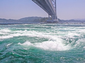
Naruto Whirlpools are the most popular and large-scale whirlpools in Japan.
The sea is a narrow strait between Naruto city and Awajishima island.
The whirlpools occur by moving of the massive amount of water between Seto Inland Sea and the Pacific Ocean by the rise and fall of the tides.
Pleasure boats approaching to the whirlpools are operated.
Cape Muroto (室戸岬, Kochi Pref.)
Cape Muroto is the cape at the south-east end of Shikoku Island.
It is located about 90 km southeast of Kochi city and about 120 km south-southwest of Tokushima city.
A ridge of the mountains slopes into the Pacific Ocean.
High priest Kuukai (774-835) started to do ascetic training in the deep mountains at the age of 19.
He stayed in a cave around Cape Muroto in his training travel.
And he attained enlightenment of Buddhism in the cave.
And there is the Buddhist temple "Hotsumisakiji" related to Kuukai on the cape.
Cape Ashizuri (足摺岬, Kochi Pref.)
Cape Ashizuri is the cape at the south-west end of Shikoku Island.
It is located about 120 km southwest of Kochi city.
The coast is very steep and rough waves of the Pacific Ocean wash the cape.
The climate is warm, so subtropical plants are seen.
There is the Buddhist temple "Kongofukuji" related to Kuukai near the cape.
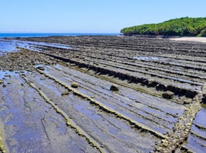
Tatsukushi (竜串, Kochi Pref.)
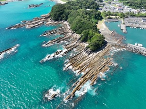
Tatsukushi is a coast with strange rocks.
It is located about 20 km northwest of Cape Ashizuri.
Sandstone and mudstone have been deposit alternating layers.
And erosion by waves of the sea has created the strange and unique rocks.
Especially, the rocky shore looks strange, just as if many huge bamboos are laid on the shore.
Kyushu Region
Mojiko Retro (門司港レトロ, Fukuoka Pref.)
Mojiko Retro is the sightseeing spot facing Kanmon Straits between Honshu island and Kyushu island.
"Mojiko" means Moji Port.
Now, the railways and the road are connected by the tunnel and the bridges.
But,
the railway ferry had been operated from opposite city Shimonoseki until 1942.
Mojiko had been the starting station of railway in Kyushu.
The buildings at that time are restored around Mojiko staion.
Umi no Nakamichi (海の中道, Fukuoka Pref.)
Umi no Nakamichi is a sand bank near Fukuoka city.
There are wide flower gardens and large grassy fields, and amusement park, zoo, etc. are set up.
Shikanoshima is connected to the sand bank, and the golden seal given from China in the 1st century was excavated in the island.
Yobuko (呼子, Saga Pref.)
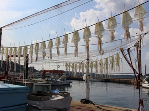
Yobuko fishing port and squids drying in the sun
Yobuko is a district facing Genkai Sea in Karatsu city in Saga Prefecture.
The squids unloaded at the fishing port are fresh and popular.
The morning market is popular and the fresh fishes and squids are sold.
There are also some sightseeing spots around the town.
Gunkanjima (軍艦島, Nagasaki Pref.)
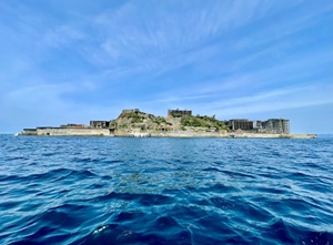
Gunkanjima is a small island near Nagasaki city.
It had been a coal mine until 1974, and it looks like a warship because many buildings and facilities are on the island.
The island is a ruin but the island is designated as the World Cultural Heritage.
A few guided tours are operated from Nagasaki Port.
Kujukushima (九十九島, Nagasaki Pref.)
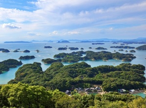
Kujukushima is a group of many small islands along the intended coast to the northwest of Sasebo city in Nagasaki Prefecture.
"Kujuku" means "99" in Japanese but it means a lot of islands.
In fact, there are over 200 islands.
The scenery is attractive and the view of sunset is beautiful.
Fukue Island (福江島, Nagasaki Pref.)
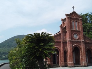
Dozaki church in Fukue Island
Fukue Island is one of Goto Islands to the west of mainland.
It is located about 100 km west of Nagasaki city.
Samurai residences in the 17th century remain.
And, there are some Christian churches built after lifting of the ban of Christianity in 1873.
Amakusa (天草, Kumamoto Pref.)
Amakusa is the islands on the west side of Kumamoto Prefecture.
There are many islands near the mainland.
Because Christianity was banned in Japan in 1587, Japanese Christians had hidden in Amaskusa until the lifting of the ban of Christianity in 1873.
So there are also a few Christian churches in Amakusa.
Aoshima (青島, Miyazaki Pref.)
Aoshima is a flat and small island.
It is located about 10 km south of Miyazaki city.
The coast is covered with the bedrocks which have regular and straight stripes of geological layers.
The scenary is rare and popular.
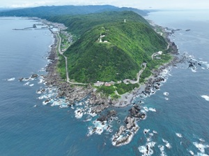
Yakushima (屋久島, Kagoshima Pref.)
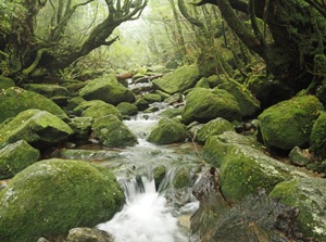
Deep forest in Yakushima
Yakushima is not so large, but very high and steep mountains tower in the island.
The island looks like a huge mountain rising out of the ocean.
The climate is warm and rainy.
So, rich forests cover the whole island and there are many cedar trees thousands of years old.
The island is designated as a World Natural Heritage site.
Yoronjima (与論島, Kagoshima Pref.)
Yoronjima is a small island surrounded by coral reef in Kagoshima Prefecture.
It is located just to the north of Okinawa Island.
It has been an resort island and there are beautiful beaches.
And, vipers live in most Okinawa islands, but they don't live in Yoronjima.
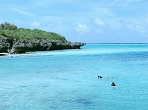
Okinawa (沖縄)
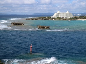
Manza Beach in Okinawa Island
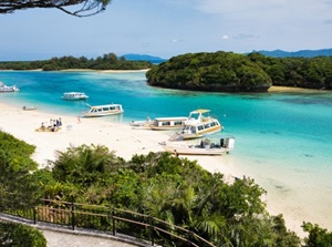
Kabira Bay in Ishigaki Island
Okinawa is the prefecture located on the southwestern edge of Japan.
Subtropical islands are dotted on a line for 650 km.
From the 15th to 19th centuries, the islands were Ryukyu Kingdom, so unique cultures remain.
Okinawa Island, Miyako Island and Ishigaki Island are the main islands.
There are many beach resorts in these islands.