
Rivers, Gorges and Waterfalls in Japan


About rivers in Japan
Japan is an island country and the shape of land is narrow and long.
The whole area is mountainous and there are a lot of rain, so many rivers flows out the mountains.
But the distances to the sea are short.
The longest river in Japan is Shinano River flowing to Niigata Prefecture, and the lenght is 367 km.
The second longast river is Tone River.
Even though it flows through the widest Kanto Plain with Tokyo and many cities, the lenghth is 322 km.
In the mountain area, many rivers flow rapidly and pure water flows.
They formed various gorges and waterfalls.
Rivers, gorges and waterfalls in eastern Japan
Hokkaido Region
Otaru Canal (小樽運河)
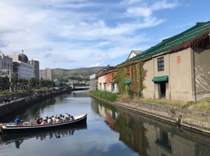
Otaru Canal is at the edge of the central part of Otaru city.
It separates the city from the harbor area.
It was built for discharging of cargo from ship in 1923.
The retro atmosphere is popular.
The cruise boat sailing on the canal and harbor is operated.
Sounkyo (層雲峡)
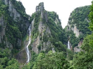
Two waterfalls in Sounkyo
Sounkyo is a gorge formed by Ishikari River.
It is located about 60 km east of Asahikawa city.
It is at the northern foot of Daisetsuzan mountains.
A few waterfalls and steep rocky cliffs are attractive.
There is the onsen town, and a ropeway to Daisetsuzan is operated.
Tohoku Region
Oirase stream (奥入瀬渓谷, Aomori Pref.)
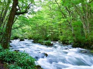
Oirase stream is the uppermost stream of Oirase River flowing from Lake Towada.
The length of main section is about 14 km.
There are many various waterfalls along the stream.
A walking trail is set up along the stream.
And, the route buses connecting Aomori city, Mount Hakkoda and Lake Towada run along this stream.
Genbikei (厳美渓, Iwate Pref.)
Genbikei is a gorge along Iwai River.
It is located about 8 km west of Ichinoseki city in Iwate Prefecture.
Strange rocks and waterfalls are seen.
And countless spherical holes on the bottom of the river are unique.
Japanese rice dumplings served in a basket from the other side of the river is popular.
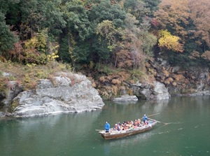
Geibikei (猊鼻渓, Iwate Pref.)
Geibikei is a gorge along Satetsu River.
It is located about 14 km northeast of Ichinoseki city in Iwate Prefecture.
There are limestone cliffs over 50 meters high along the river.
And, strange rocks, waterfalls and limestone caves are dotted.
A small pleasure boat rowed by boatmen is operated.
Oyasukyo (小安峡, Akita Pref.)
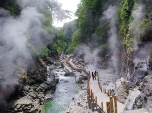
Oyasukyo is a gorge along Minase River.
It is located about 25 km southeast of Yuzawa city in the southern part of Akita Prefecture.
There are small waterfalls from the cliffs at some points.
Hot water of 98 degrees celsius is gushing from many gaps of the rocks, so the steam is rising up around the gorge.
The walking trail is set up in the steam.
Mogami River (最上川, Yamagata Pref.)
Mogami River is the main river in Yamagata Prefecture.
It flows in the center of the prefecture and main cities are along the river.
The width of the river is totally wide, so it had been the important traffic route in the area in old times.
The boat tours are operated in the middle reach.
Kanto Region
Fukuroda Falls (袋田の滝, Ibaraki Pref.)
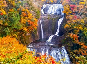
Fukuroda Falls is a waterfall in the Takigawa River.
It is in the mountain located the northern part of Ibaraki Prefecture.
The falls consist of four consecutive waterfalls and the height is 120 meters.
It is designated as National Scenic Beauty.
There are two observatories for the falls.
Kegon Falls (華厳の滝, Tochigi Pref.)

Kegon Falls are one of most popular spots in Nikko.
It is located about 10 km west of the main town of Nikko.
It falls down from Lake Chuzenji, and the height is 97 meters.
There is an observatory with elevator near the falls.
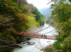
Ryuokyo (龍王峡, Tochigi Pref.)
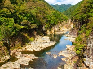
Ryuokyo is a gorge in Kinu River.
It is located about 20 km north of the main town of Nikko.
And, there is Kinugawa and Kawaji Onsen resorts near the gorge.
Both riversides are steep rocky cliffs, and there are several strange rocks and waterfalls.
"Ryuo" means "King of Dragon", because the river winds like a dragon.
Fukiware Waterfalls (吹割の滝, Gunma Pref.)
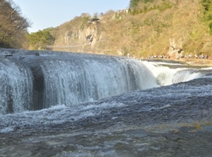
Fukiware Waterfalls are in a Fukiware Gorge formed by Katashina River.
It is located about 20 km west of Numata city in the northern part of Gunma Prefecture.
There is a long large crack in the river and the height is about 7 meters.
The unique scenery is like Niagara Falls between USA and Canada.
Junikyo (十二橋, Chiba & Ibaraki Prefs.)
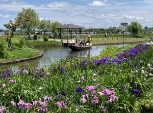
Suigo Sawara Iris Park
Junikyo are the twelve small bridges over the narrow canal.
The area is in Itako city in Ibaraku Prefecture and Katori city in Chiba Prefecture.
The area is in the lower section of large Tone River, so many canals had been the ways in the daily life.
Iris gardens are well-known.
The boat cruises visiting Junikyo is popular.
Nomizo Falls (濃溝の滝, Chiba Pref.)
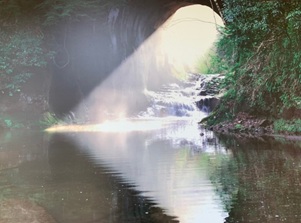
Nomizo Falls is in the mountain in Kimitsu city in Chiba Prefecture.
A tunnel was dug for an irrigation channel in the ancient times, the stream flows like the small and low falls in the tunnel.
The scenery through a tunnel looks like the shape of heart.
It became popular by social media around 2015.
Nagatoro (長瀞, Saitama Pref.)
Nagatoro is a gorge on the upper part of Arakawa River flowing to Tokyo.
It is located in the western part of Saitama Prefecture.
The gorge is about 6 km long, and there are various rocks and cliffs which are geologically interesting.
So, it was designated as a national nature treasure and a beauty spot.
The tourists can see various spots from small boat.
Sumida River (隅田川, Tokyo)
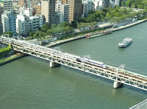
Sumida River around Asakusa
Sumida River is a branch river of Arakawa and is flowing through the east side of central Tokyo.
It flows along some popular spots such as Asakusa, Ryogoku, Nihonbashi, Ginza, Odaiba and Tokyo Port.
The width of the river is over 100 meters and water buses are operated frequently.
Rivers, gorges and waterfalls in central Japan
Koshin-etsu Region
Shosenkyo (昇仙峡, Yamanashi Pref.)
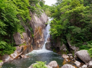
A waterfall in Shosenkyo
Shosenkyo is a gorge located about 10 km north of Kofu city in Yamanashi Prefecture.
There are a lot of strange rocks along the river at the bottom of the deep gorge.
There are some unique scenic spots such as rocky cliffs, a tunnel of big rocks, and waterfalls.
Nezame-no-toko (寝覚の床, Nagano Pref.)
Nezame-no-toko is a gorge formed by Kiso River.
It is located in Agematsu town in the southwestern part of Nagano Prefecture.
"Nezame-no-toko" means "bed when awakening".
As its name suggests, there is a huge flat rock in the gorge.
The river has been eroding the granite bedrock, so there are many rectangular rocks and vertical walls of the rock.
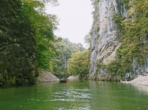
Tenryukyo (天竜峡, Nagano Pref.)
Tenryukyo is a gorge formed by Tenryu River.
The river frows from Lake Suwa in the center of Nagano Prefecture to the south.
It is a gorge in the middle reach of the river, and narrow and steep valley has been formed.
The tours by boat are operated.
Kiyotsukyo (清津峡, Niigata Pref.)
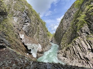
Kiyotsukyo is a gorge near Echigo-Yuzawa town which is popular for ski resorts in Niigata Prefecture.
The walls of the huge and steep cliffs are formed with numerous column-shaped rocks.
To see the gorge, the visitors pass through a long tunnel.
The exit of the tunnel is the observatory for the gorge.
Hokuriku Region
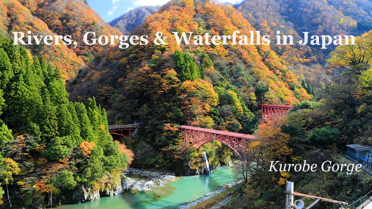
Kurobe Gorge (黒部峡谷, Toyama Pref.)

Kurobe Gorge is a very steep and long gorge formed by Kurobe River flowing through the Northern Alps.
It is located in the eastern part of Toyama Prefecture.
There is Kurobe Dam on the upper reaches of the river.
There is Unazuki Onsen resort at the entrance of the gorge and Kurobe Gorge Railway leads to the middle reach of the river.
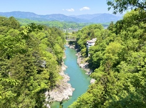
Shogawa Gorge (庄川峡, Toyama Pref.)
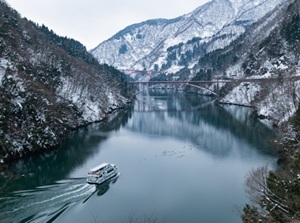
Shogawa Gorge in winter
Shogawa Gorge is a gorge formed by Shogawa river flowing in the western part of Toyama Prefecture.
The winding dam lake is the main part, and the surface of the river is very calm.
The mountains on the both sides of the river are covered with deep forest.
A cruising ship is operated.
Tokai Region
Shiraito Falls (白糸の滝, Shizuoka Pref.)
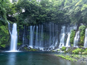
Shiraito Falls is at the west-southwestern foot of Mount Fuji.
The waterfall is about 20 meters high and about 150 meters wide.
Melted snow water on Mount Fuji sinks through the ground, and the water comes out here after many years.
"Shiraito" means "white thread".
The falling water looks like many hanging silken threads.
Joren Falls (浄蓮の滝, Shizuoka Pref.)
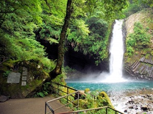
Joren Falls is a popular waterfall in the center of Izu Peninsula in Shizuoka Prefecture.
It is about 25 meters high and 7 meters wide, and rich water falls swiftly.
Kawabata Yasunari who won the nobel prize for literature wrote a novel set at the waterfalls, so here is a popular sightseeing place.
There are Yugashima onsen resort and some other sightseeing spots around the falls.
Guide to Joren Falls around Mt.Amagi
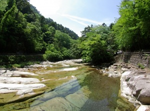
Sumata Gorge (寸又峡, Shizuoka Pref.)
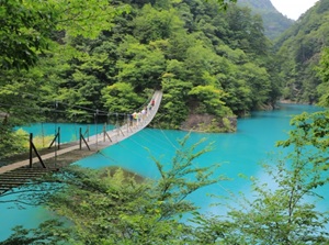
Sumata Gorge is a steep gorge in a branch river located in the upper reaches of Oigawa river in Shizuoka Prefecture.
There is a small onsen resort and a walking trail leads to the gorge.
And, a suspension bridge crossing over the dam lake is popular.
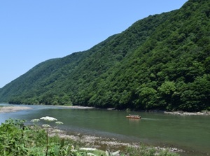
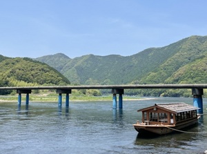
Nagara River (長良川, Gifu Pref.)
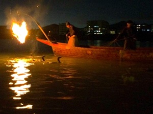
Ukai in Nagara River
Nagara River flows through Gifu city and it is known as the clear waters.
Ukai is an old fishing method to catch Ayu sweetfish using cormorants.
It is said that the ukai in Nagara River has been conducted for around 1,300 years.
The fishing is held from mid-May to mid-October.
The performance for tourist is seen as a show on the boat in the evening.
Guide to Nagara River in Gifu city
Yoro Falls (養老の滝, Gifu Pref.)
Yoro Falls is the waterfalls in small Yoro Mountains range.
It is located about 30 km southwest of Gifu city.
The height is 32 meters and the width is about 4 meters.
The water is clear and tasty.
There is a legend that the water changed to tasty Sake for a dutiful son who takes care of his old father.
But, the water for you will not become Sake.
Akame 48 Waterfalls (赤目四十八滝, Mie Pref.)
Akame 48 Waterfalls are in the gorge about 4 km long.
The gorge is located about 10 km south of Nabari city in Mie Prefecture.
It is said that the number of the waterfalls are more than 48.
Japanese giant salamander, a special natural treasure, lives in the clear river.
It is close to Iga city, and it is said that Iga Ninja had trained around these waterfalls in Edo Period.
Rivers, gorges and waterfalls in western Japan
Kansai Region
Arashiyama (嵐山, Kyoto city)
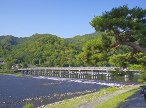
Arashiyama is a popular district along Katsura River.
It is located in the northwestern part of central Kyoto.
Togetsukyo bridge across Katsura River is the central spot.
There are Tenryuji temple, Path of Bamboo grove, etc. in the district.
Hozu gorge (保津峡, Kyoto Pref.)
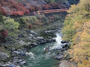
Hozu gorge is a gorge formed by Hozu River.
Hozu River is upstream of Katsura River in Arashiyama.
The length of the gorge is about 12 km.
Cruising by small boat is operated between Arashiyama and Kameoka city.
And, a sightseeing train runs along the gorge.
Dotonbori (道頓堀, Osaka)
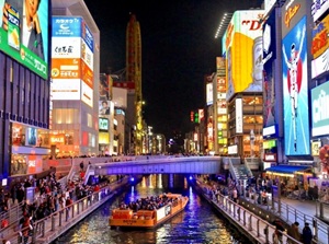
Dotonbori is a river constructed as a canal in the early 17th century.
The area along the river is very popular for a downtown of Osaka.
Ebisu Bridge in the center part of the river is also a popular spot.
The boat cruising is operated.
Doro Gorge (瀞峡, Wakayama Pref.)
Doro Gorge is a gorge formed by Kitayama River.
It is located about 30 km north of Shingu city in Wakayama Prefecture.
The area is deep in the mountain and only a few small villages are dotted along the river.
The river contains a great volume of water, and many high cliffs, huge rocks, strange rocks and caves are seen.
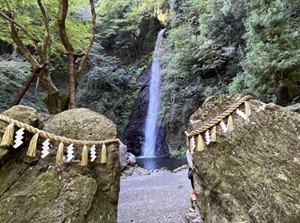
Nachi Falls (那智滝, Wakayama Pref.)
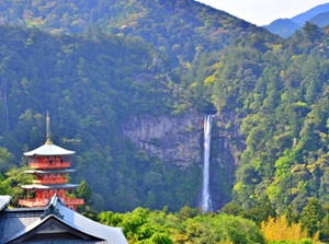
Nachi Falls is a popular falls 133 m high.
It is located about 7 km north of Kii-Katsura onsen resort in the southeastern part of Wakayama Prefcture.
There is Kumano Nachi Taisha near this waterfall.
It has been an object of worship of the shrine.
It is one of the destinations of "Kumano Kodo" pilgrimage routes.
Chugoku Region
Sandankyo (三段峡, Hiroshima Pref.)
Sandankyo is a gorge in the deep mountain in Hiroshima Prefecture.
It is around the upper Ota river and the river flows down to Hiroshima city.
It is located about 50 km northwest of Hiroshima city.
The gorge is about 16 km long and the walking trail 12 km long is set up.
Some water falls and various streams are seen.
Kintai Bridge (錦帯橋, Yamaguchi Pref.)
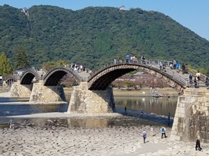
Kintai Bridge is a unique wooden arch bridge crossing over Nishiki River in Iwakuni city in Yamaguchi Prefecture.
The original bridge was built to connect Iwakuni castle and the castle town in 1673.
Iwakuni Castle is on the top of the mountain near the bridge.
The main structural part of the bridge is assembled elaborately with only woods without nail and clamp.
Amedaki (雨滝, Tottori Pref.)
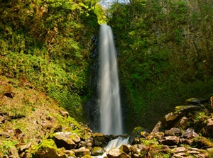
Amedaki is the waterfall to the east of Tottori city.
It is located about 20 km east of Tottori city and at an altitude of about 500 meters.
The area around this waterfall has been a place where a Buddhist priest practices asceticism since ancient times.
Shikoku Region
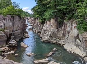
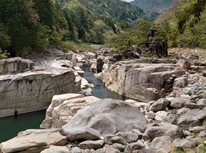
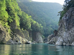
Oboke, Koboke (大歩危, 小歩危, Tokushima Pref.)
Oboke gorge
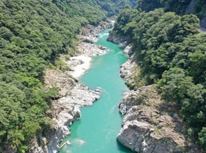
Koboke gorge
Oboke and Koboke are the deep gorges formed by Yoshino River in Tokushima Prefecture.
Oboke has very rough rocks and river flows with a volume of water.
Koboke is about 6 km downstream of Oboke, and it is narrower, more winding, and faster river flows than Oboke.
Iya valley (祖谷渓, Tokushima Pref.)
Iya valley is a huge V-shaped valley in the deep mountains.
It is located on the other side of the mountains of Oboke and Koboke gorges.
We can see the people's life in the small village on the steep area.
It is one of mysterious lands of Japan.
The vine bridge across the river is popular.
Shimanto River (四万十川, Kochi Pref.)
A sinking bridge in Shimanto River
Shimanto River flows in the southwest part of Kochi Prefecture.
It is remote from major cities and does not have any dams.
Therefore, it is often referred to as the last clear stream of Japan.
There are unique "sinking bridges" to be carried away by the flood on purpose.
Omogo Gorge (面河渓, Ehime Pref.)
Omogo Gorge is a gorge formed by Omogo River.
It is located about 50 km southeast of Matsuyama city in Ehime Prefecture.
Mount Ishizuchi (1,982 m) which is the highest mountain in Shikoku Island is located about 7 km north of this gorge.
There are some attractive spots along the gorge.
Kyushu Region
Yanagawa (柳川, Fukuoka Pref.)
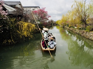
Yanagawa is a castle city near Ariake Sea in Fukuoka Prefecture.
Many canals connecting to the rivers were constructed to defense of the castle.
These are attractive, so Yanagawa is often called the city of water.
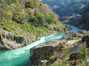
Kuma River (球磨川, Kumamoto Pref.)
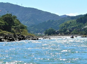
Kuma River flows in the south part of Kumamoto Prefecture.
The section from Hitoyoshi to Yatsushiro cities is a narrow valley about 50 km long.
It has one of the swiftest currents in Japan.
The tours floating down the river are conducted near Hitoyoshi city.
Yabakei (耶馬渓, Oita Pref.)
Yabakei is a gorge formed by Yamakuni River in Oita Prefecture.
We can see many rocky cliffs and caves along the river.
There is a tunnel 144 m long which was chiseled by a priest and masons in the 1730s.
And, Rakanji temple with stone Buddha statues in the cave is unique near Yabakei.
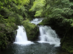
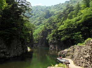
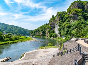
Takachiho Gorge (高千穂峡, Miyazaki Pref.)
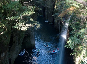
Takachiho Gorge is a gorge formed by Gokase River.
Because the rock is tuff, it is not so hard.
So, most of the cliffs in this gorge are very steep.
The gorge with Manai Falls is popular, so you can use the rental boat to enjoy the gorge.